Hurricane Information for Kids: The Science of the Spin
Table of Contents
Hurricane Information: Hurricanes rank amongst nature’s most powerful and awe-inspiring weather phenomena. These massive rotating storms can stretch hundreds of kilometres across, produce winds exceeding 250 kilometres per hour, and release energy equivalent to numerous atomic bombs. Understanding how hurricanes form, why they spin, and what makes them so destructive helps us appreciate both the power of nature and the importance of weather science in keeping people safe.

For young learners curious about our planet’s weather systems, hurricanes offer a fascinating glimpse into atmospheric physics, ocean dynamics, and the forces that shape our climate. Whilst these storms can be frightening and dangerous, learning about the science behind them transforms fear into knowledge and respect. By understanding hurricanes, children gain valuable insights into meteorology. Emergency preparedness and the interconnected systems that govern Earth’s weather patterns.
Every year, tropical regions around the world experience hurricane season, when atmospheric and oceanic conditions align to create these powerful storms. Coastal communities prepare for potential impacts, meteorologists monitor weather patterns with sophisticated technology, and emergency services stand ready to respond. For children living in hurricane-prone areas, understanding these storms isn’t merely academic—it’s essential knowledge that helps families stay safe and make informed decisions when warnings are issued.
The swirling, spiral shape of hurricanes visible from satellites has captivated people since the space age began, revealing patterns that our ancestors could only imagine. These images show Earth’s weather as a dynamic, constantly changing system where massive storm systems develop, intensify, move across oceans, and eventually dissipate.
The elegant spiral structure isn’t random chaos but rather the visible manifestation of physical laws governing our atmosphere, making hurricanes perfect examples of how science helps us understand and predict natural phenomena that affect millions of people worldwide.
This exploration of hurricane science examines the fundamental principles that create these spinning giants, the conditions required for their formation, and the reasons why they rotate with such distinctive circular motion. From the warm tropical waters that fuel their development to the Coriolis effect that sets them spinning, each aspect of hurricane formation reveals remarkable scientific principles at work in our atmosphere.
What Are Hurricanes?

Hurricanes are powerful tropical cyclones—rotating storm systems that develop over warm ocean waters near the equator. These weather systems go by different names depending on where they occur around the world. In the Atlantic Ocean and Eastern Pacific, they’re called hurricanes. In the Western Pacific, the same type of storm is known as a typhoon. In the Indian Ocean and South Pacific, meteorologists refer to them as cyclones. Regardless of the name, all these storms share the same basic structure and formation process.
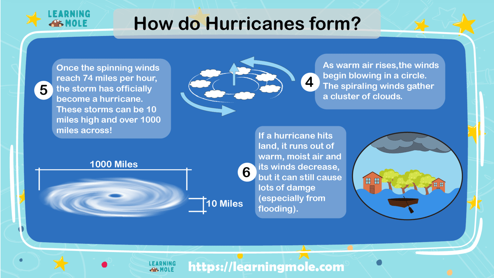
At their core, hurricanes are heat engines that transform the thermal energy stored in warm ocean water into powerful winds and torrential rainfall. The storm’s distinctive spiral shape, with bands of clouds rotating around a calm central eye, creates one of the most recognisable patterns in meteorology. These rotating systems can measure anywhere from 100 to over 1,000 kilometres in diameter, with the most intense winds concentrated in a ring called the eyewall that surrounds the calm eye at the storm’s centre.
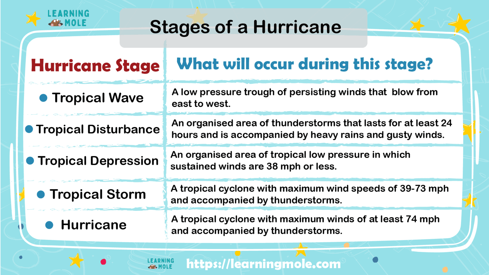
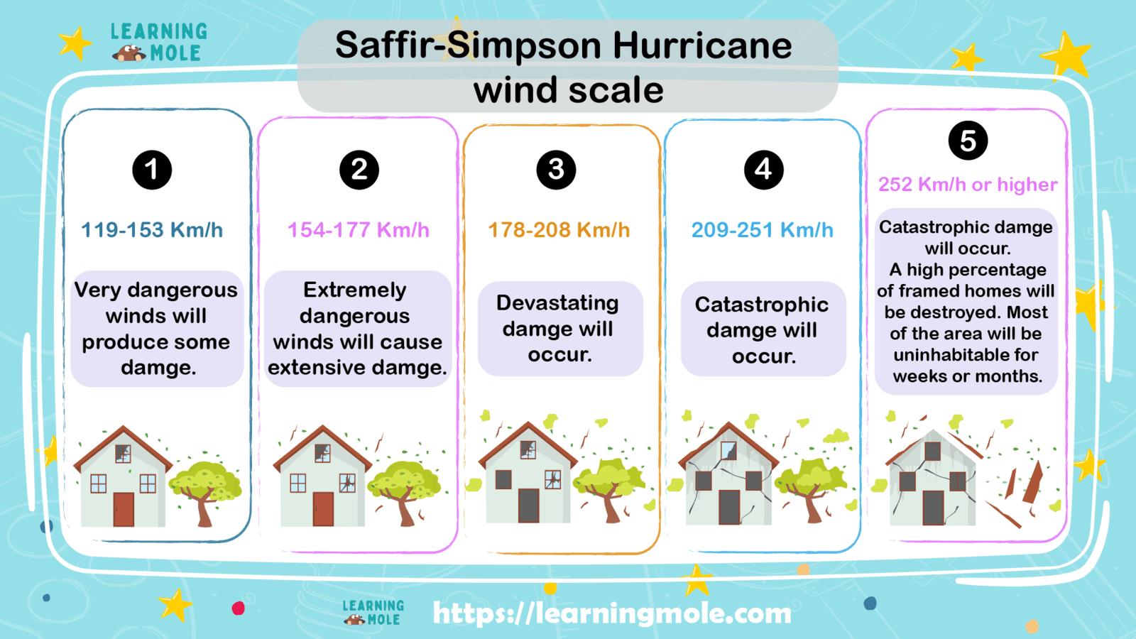
Hurricanes are classified according to their wind speed using the Saffir-Simpson Hurricane Wind Scale, which ranges from Category 1 (weakest) to Category 5 (strongest). A Category 1 hurricane features sustained winds of 119-153 kilometres per hour, whilst a Category 5 monster produces winds exceeding 252 kilometres per hour. Each category increase represents significantly greater destructive potential, with stronger hurricanes capable of causing catastrophic damage to buildings, infrastructure, and natural environments.
The Birth of a Hurricane: Perfect Conditions Required

Hurricanes don’t form randomly—they require very specific conditions to develop. Think of these conditions as ingredients in a recipe; if any ingredient is missing, the hurricane won’t form properly. Scientists have identified several essential requirements that must all be present simultaneously for a hurricane to develop.
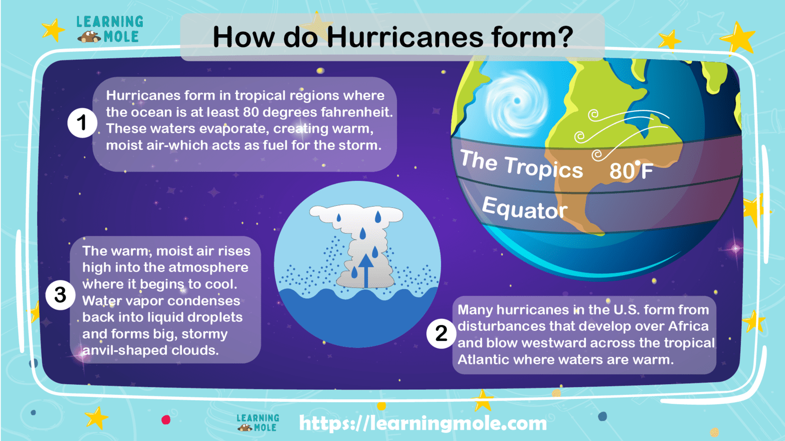
First and foremost, hurricanes need warm ocean water—specifically, sea surface temperatures of at least 26.5 degrees Celsius extending to a depth of about 50 metres. This warm water serves as the fuel for the storm, providing the heat and moisture that power the hurricane’s development. The warmer the water, the more energy available to strengthen the storm. This explains why hurricane season in the Atlantic Ocean runs from June through November, when ocean temperatures peak in tropical regions.
The second crucial ingredient involves atmospheric conditions. Hurricanes require low wind shear, which refers to the change in wind speed and direction with altitude. High wind shear tears developing storms apart before they can organise into hurricanes. When winds at different altitudes blow in roughly the same direction and speed, the storm can maintain its vertical structure and continue strengthening. Additionally, the atmosphere must be relatively moist, particularly in the middle levels, to support the thunderstorms that comprise the hurricane’s structure.
Distance from the equator plays a surprisingly important role in hurricane formation. Whilst hurricanes need tropical warmth, they cannot form within about 500 kilometres of the equator. This geographical restriction relates directly to the Coriolis effect, which we’ll explore in detail later. Near the equator, the Coriolis effect is too weak to initiate the rotation necessary for hurricane development. Most hurricanes form between 5 and 20 degrees latitude north and south of the equator, where conditions favour both warmth and sufficient Coriolis force.
Pre-existing weather disturbances also contribute to hurricane formation. Hurricanes often develop from tropical waves—areas of low pressure that move across the tropical Atlantic from Africa. These disturbances provide the initial organisation and lift needed to start thunderstorm development. Once thunderstorms begin clustering together over warm water with favourable atmospheric conditions, the process of hurricane formation can commence.
The Science Behind the Spin: Understanding the Coriolis Effect

The distinctive rotation that defines hurricanes results primarily from a phenomenon called the Coriolis effect, named after French mathematician Gaspard-Gustave de Coriolis, who described it in 1835. Understanding this effect requires recognising that Earth constantly rotates on its axis, completing one full rotation every 24 hours. Whilst we don’t feel this rotation in our daily lives, it profoundly influences large-scale movements in both the atmosphere and oceans.
To visualise the Coriolis effect, imagine standing at the North Pole and throwing a ball to a friend standing near the equator. The ball would travel in a straight line through space, but because Earth rotates beneath it, the ball would appear to curve to the right from your perspective. This apparent deflection occurs because different parts of Earth rotate at different speeds—the equator moves faster than locations closer to the poles. This deflection affects all moving objects on Earth, including air masses in the atmosphere.
In the Northern Hemisphere, the Coriolis effect deflects moving air to the right of its direction of travel. In the Southern Hemisphere, it deflects air to the left. This deflection becomes more pronounced the farther an object travels, and the longer it remains in motion. For slow-moving or small-scale phenomena, the Coriolis effect is negligible. However, for massive air masses moving across hundreds or thousands of kilometres over several days—like those in hurricanes—the effect becomes dominant.
When air begins rushing towards a low-pressure area over warm tropical waters, the Coriolis effect causes this converging air to rotate rather than flow straight inward. In the Northern Hemisphere, hurricanes spin anticlockwise (counterclockwise), whilst Southern Hemisphere cyclones rotate clockwise. This rotation intensifies as the storm develops, creating the characteristic spiral structure visible in satellite images. The faster the winds blow towards the centre, the stronger the Coriolis deflection, resulting in tighter and more intense rotation.
The Coriolis effect explains why hurricanes cannot form at the equator despite the presence of warm water. At the equator, the Coriolis force is zero—there’s no deflection to initiate rotation. As latitude increases, the Coriolis effect strengthens, which is why hurricanes form in tropical regions away from the equator but rarely in temperate zones where ocean temperatures are typically too cool.
Anatomy of a Hurricane: Understanding the Structure

A fully developed hurricane displays remarkable structural organisation despite being composed of chaotic, violent weather. Understanding this structure helps explain how hurricanes work and why different parts of the storm produce different impacts.
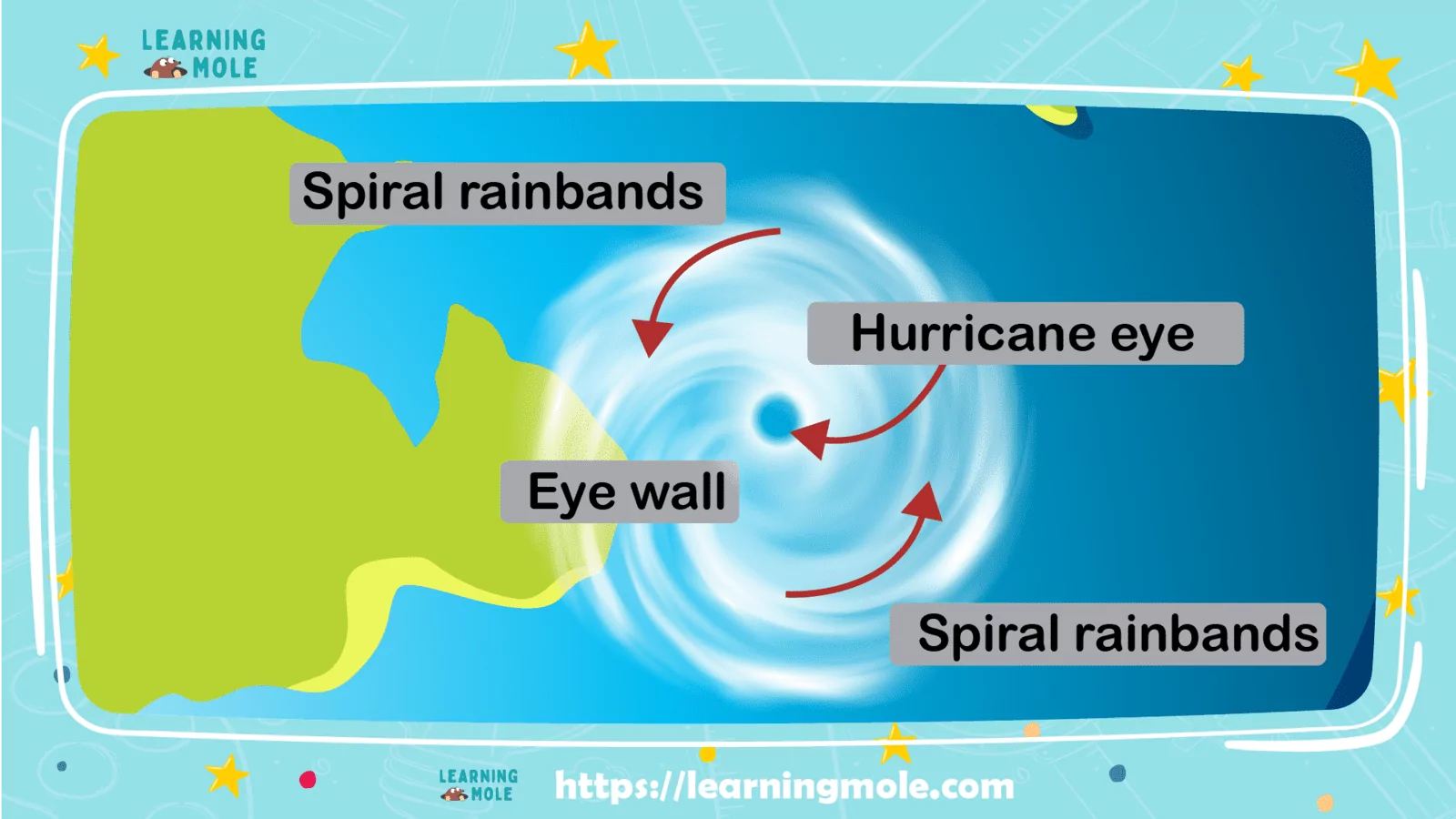
The eye represents the hurricane’s most distinctive feature—a relatively calm area at the storm’s centre where skies may be partly cloudy or even clear. The eye typically measures 30-65 kilometres in diameter, though some powerful hurricanes develop eyes as small as a few kilometres or as large as 100 kilometres across. Inside the eye, winds are light, and conditions are relatively tranquil compared to the surrounding storm. This calmness results from descending air in the eye, which warms and dries as it sinks, inhibiting cloud formation.
Surrounding the eye lies the eyewall, a ring of towering thunderstorms that contains the hurricane’s strongest winds and heaviest rainfall. The eyewall represents the most dangerous part of the hurricane, where maximum sustained winds occur and where the most intense weather batters anything in the storm’s path. Air rises rapidly in the eyewall, creating powerful updrafts that can reach altitudes of 15 kilometres or more. As this air ascends, it cools and releases tremendous amounts of moisture as torrential rain.
Spiral rainbands extend outward from the eyewall like curved spokes on a wheel. These bands of thunderstorms can stretch for hundreds of kilometres from the hurricane’s centre, bringing heavy rain, strong winds, and occasionally tornadoes to areas far from the eye. The rainbands don’t form a solid shield of clouds but rather appear as distinct curved lines of storms separated by relatively calm areas. These bands continuously feed moisture and energy into the hurricane’s circulation.
The hurricane operates as a massive heat engine with distinct inflow and outflow patterns. Near the ocean surface, air spirals inward towards the low-pressure centre, gathering heat and moisture from the warm water below. This air rises rapidly in the eyewall, releasing latent heat as water vapour condenses into clouds and rain. At high altitudes, the air spreads outward from the centre, creating an outflow layer that carries away the rising air, maintaining the low pressure at the surface and allowing more air to spiral inward. This continuous cycle keeps the hurricane energised as long as it remains over warm water.
How Hurricanes Intensify and Weaken

Hurricane intensity depends on maintaining the delicate balance of conditions that support its development. Understanding what strengthens or weakens these storms helps meteorologists predict their behaviour and potential impacts.
Hurricanes intensify when they can maintain a strong inflow of warm, moist air near the surface while efficiently removing air aloft through upper-level outflow. The warmer and deeper the ocean water, the more heat energy available to power the storm. When a hurricane encounters exceptionally warm water or warm ocean currents, it can rapidly intensify, sometimes strengthening by multiple categories within 24 hours. This rapid intensification presents particular challenges for forecasters and emergency managers who must warn coastal populations of approaching danger.
Conversely, several factors can weaken hurricanes. Moving over cooler water cuts off the storm’s primary energy source, causing it to lose strength. This explains why hurricanes typically weaken rapidly after making landfall—they lose access to the warm ocean water that powers them. Increased wind shear can disrupt the hurricane’s structure, preventing the efficient vertical organisation required to maintain intensity. Dry air entering the circulation can also weaken the storm by inhibiting thunderstorm development and rainfall.
Interaction with land plays a complex role in hurricane behaviour. Whilst moving over land always weakens a hurricane by cutting off its ocean energy source, the terrain itself can influence the storm’s structure. Mountains can disrupt circulation patterns, whilst friction with the land surface slows wind speeds near the ground. However, the hurricane’s size means that damaging winds and heavy rainfall can continue for many hours or even days after landfall, particularly if the storm moves slowly.
Hurricane Impacts and Hazards

Hurricanes present multiple dangerous hazards, each capable of causing significant destruction and loss of life. Understanding these hazards helps communities prepare and respond effectively when storms threaten.
Extreme winds represent the most obvious hurricane danger, with the strongest storms producing sustained winds exceeding 250 kilometres per hour and gusts even higher. These winds can destroy buildings, uproot trees, turn debris into dangerous projectiles, and make areas uninhabitable for weeks or months. The Saffir-Simpson scale specifically categorises hurricanes by wind speed because wind damage increases dramatically with each category level.
Storm surge often proves the deadliest hurricane hazard. This phenomenon occurs when hurricane winds push ocean water towards the coast, creating a dome of water that rises above normal sea level. Storm surge can raise water levels by several metres, flooding coastal areas and causing catastrophic damage. The surge arrives ahead of the hurricane’s eye, often catching people by surprise. When storm surge coincides with high tide, flooding becomes even more severe.
Torrential rainfall from hurricanes can produce catastrophic flooding far from the coast. Slow-moving hurricanes pose particular flooding threats because they can drop tremendous rainfall totals—sometimes exceeding 500 millimetres—over the same area for extended periods. This rainfall can cause rivers to overflow, trigger flash floods, and create landslides in mountainous areas. Inland flooding from hurricane rainfall sometimes causes more damage than wind or storm surge.
Tornadoes frequently develop in the outer rainbands of hurricanes, particularly in the right-front quadrant of the storm (relative to its direction of movement) in Northern Hemisphere hurricanes. Whilst these tornadoes are typically weaker than those produced by severe thunderstorms in temperate regions, they still pose additional threats to life and property.
Predicting and Preparing for Hurricanes

Modern meteorology has made tremendous progress in predicting hurricane tracks and intensity, giving communities valuable time to prepare for approaching storms. Meteorologists use sophisticated computer models, satellite imagery, aircraft reconnaissance, and ocean buoys to monitor and forecast hurricane behaviour.
Hurricane hunter aircraft fly directly into storms, deploying instruments that measure wind speed, atmospheric pressure, temperature, and humidity. These brave pilots and scientists gather crucial data that helps forecasters understand the hurricane’s current strength and structure. Satellites provide continuous monitoring from space, tracking cloud patterns, measuring sea surface temperatures, and observing storm development across entire ocean basins.
Forecasters can now predict hurricane tracks with reasonable accuracy several days in advance, allowing authorities to issue timely warnings and evacuation orders. However, predicting intensity changes remains more challenging, particularly for rapid intensification events. Meteorologists continue working to improve intensity forecasts, as knowing whether a Category 2 hurricane will strengthen to Category 4 before landfall dramatically affects evacuation and preparation decisions.
Conclusion
Understanding the science behind hurricanes—from the warm ocean waters that fuel them to the Coriolis effect that sets them spinning—transforms these dangerous storms from terrifying mysteries into comprehensible natural phenomena. The distinctive spiral structure, the calm eye surrounded by violent eyewall winds, and the spiral rainbands extending hundreds of kilometres all result from fundamental physical principles governing atmospheric behaviour.
For young learners, studying hurricanes offers valuable lessons extending beyond meteorology. These storms demonstrate the power of scientific observation and prediction, showing how knowledge and technology help protect communities from natural hazards. Understanding hurricanes also highlights the interconnected nature of Earth’s systems, where ocean temperatures, atmospheric circulation, and planetary rotation combine to create these remarkable weather events.
As climate change warms our oceans and alters atmospheric patterns, understanding hurricanes becomes increasingly important. Warmer water temperatures may fuel more intense storms, whilst rising sea levels exacerbate storm surge flooding. Future generations will need a strong scientific understanding to adapt to changing hurricane patterns and protect vulnerable coastal communities. By learning about hurricane science today, young people gain tools to become informed citizens capable of making wise decisions about preparedness, climate action, and environmental stewardship tomorrow.


Leave a Reply