Kids usually have many questions about hurricanes. What are hurricanes? How do they form? What are the most famous hurricanes? Where can hurricanes be found? What is the biggest hurricane? So we will cover some hurricane facts.
Many articles and videos introduce really useful information about hurricanes for kids. One of the most interesting ways for kids to be taught about hurricanes is through activities. When they make projects about hurricanes, they understand them better.
A hurricane is a kind of giant storm that results in heavy rainfall. There are some reasons why hurricanes form. Some changes happen during hurricanes. Hurricanes have damaging effects. In this article, we introduce almost all the information about hurricanes in the form of 11 Hurricane facts:
A hurricane is a huge rotating storm with strong winds at speeds of 75 to 200 mph that forms over warm waters in tropical areas. They usually form in the sea. The word hurricane goes back to “Huracan,” the name of a Mayan god. It is the god of big winds and evil spirits.
Hurricane season starts from the beginning of June till the end of November. Mid-September is considered the peak of the hurricane season. Coastal zones are most prone to the dangers of hurricanes. In addition to this, each hurricane lasts for over a week.
Hurricanes have different names according to their locations. In North America and the Caribbean, hurricanes are called hurricanes. In the Indian Ocean, hurricanes are given the name cyclones. They are given the name typhoons in Southeast Asia.
Hurricane facts: How do Hurricanes form?
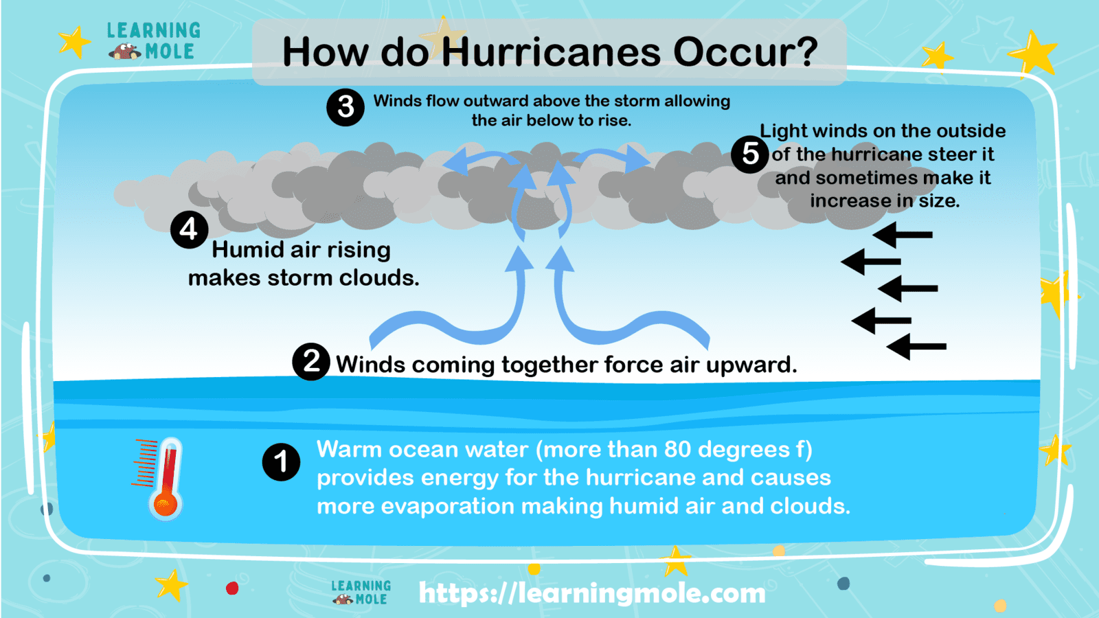
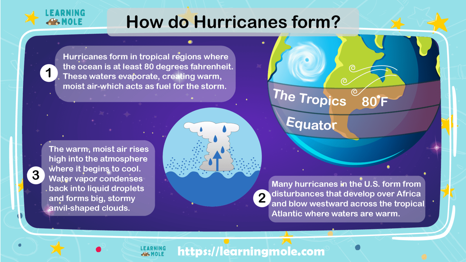
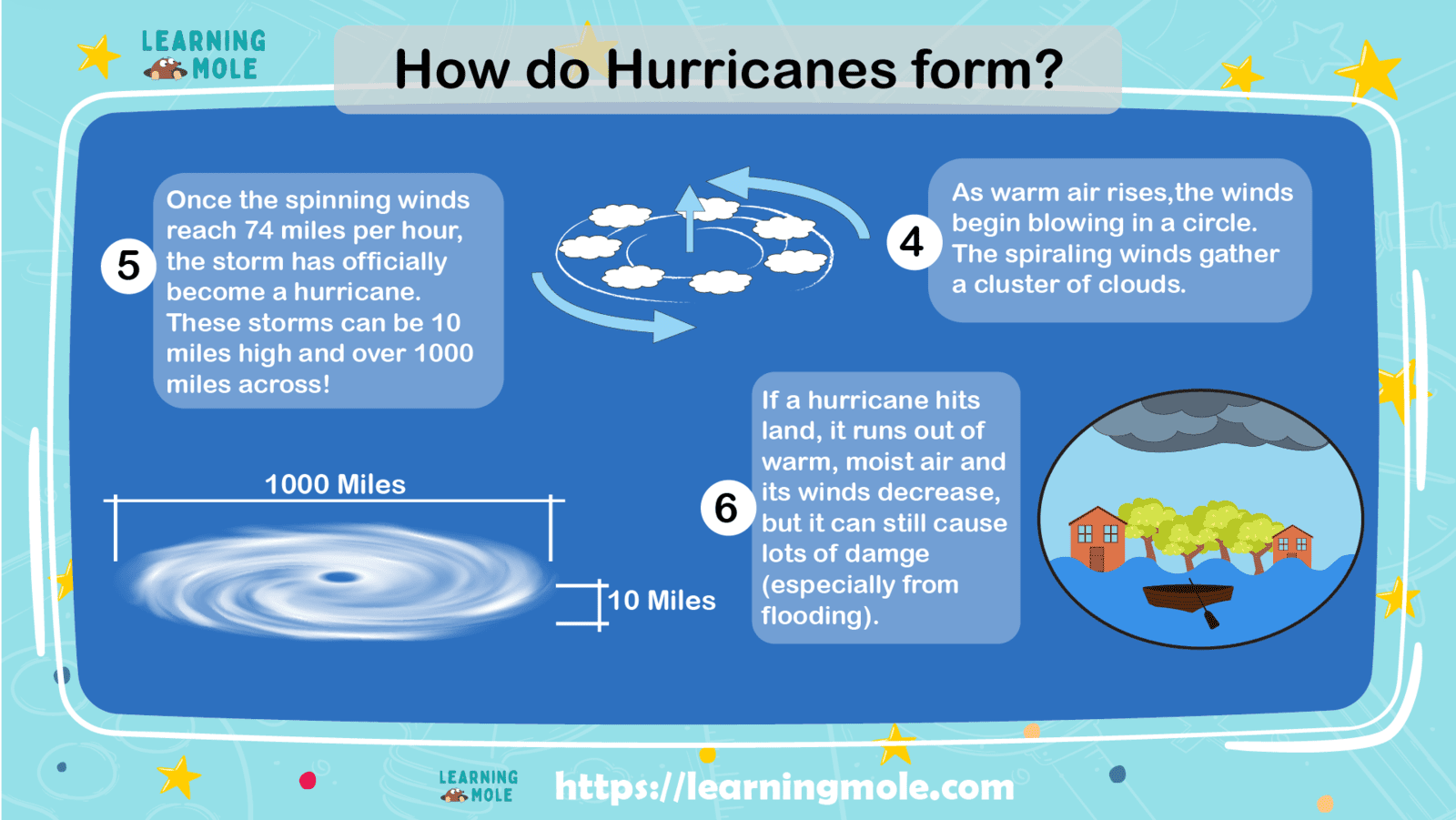
Hurricanes form over the warm ocean water of the tropics when the warm moist air over water starts to rise. The moist warm water is replaced by cooler water which in return starts to rise. This cycle results in huge storm clouds that start to rotate. These huge storm clouds, along with wind speeds, form a hurricane.
How do hurricanes form?How do hurricanes form?
Hurricane facts: What are the Parts of Hurricanes?
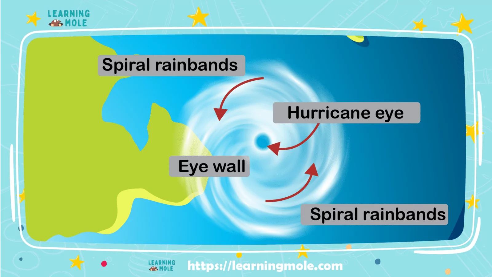
There are five parts of hurricanes:
Eye: it is at the centre of the hurricane. It is an area of descending air. There are not usually any clouds in the eye and the wind there is calm. However, the most dangerous part of the storm is at the edge of the eye which is called the eyewall.
Eyewall: it is around the outside of the eye. It is a wall formed of very heavy clouds. This is considered the most fatal part of the hurricane and where the highest speed winds are. The winds at the eyewall can get to speeds of 155 miles per hour.
Rainbands: hurricanes contain large spiral bands of rain called rainbands. These bands can throw down huge amounts of rainfall causing flooding when the hurricane crashes land.
Diameter: hurricanes can turn into huge storms. The diameter of the hurricane is calculated from one side to the other. Hurricanes can measure a diameter of over 600 miles.
Height: the storm clouds that give hurricanes power can become very tall. A powerful hurricane can go up to nine miles into the atmosphere.
Parts of a Hurricane for Kids
Hurricane facts: What are the Stages of Hurricane?
A hurricane has 6 stages as follows:
Disturbance Formation
Tropical Disturbance
Tropical Depression
Tropical Storm
Hurricane
Dissipation
Disturbance Formation
The first stage of a hurricane starts with disturbance formation. Hurricanes are made of a mixture of many factors. A hurricane starts to form due to the evaporation that happens over tropical ocean waters.
Once it starts to evaporate, a cloud of warm air begins to shape, heating the air around it and forming even more densely packed clouds as air rushes in. As the air still heats up, a large mass of warm rain clouds is formed over the ocean.
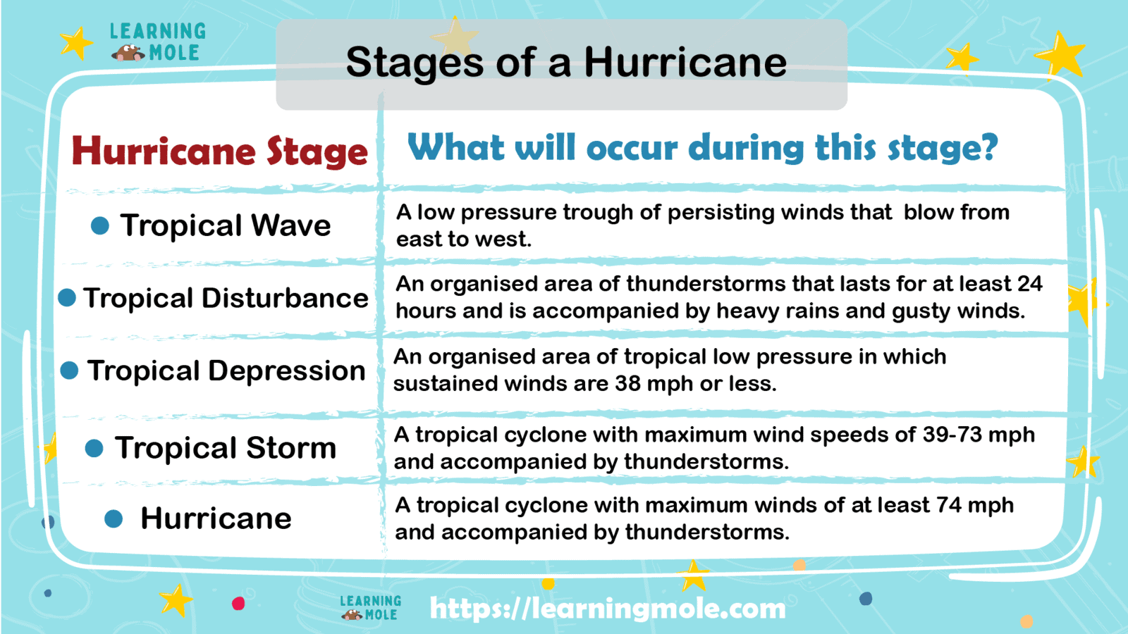
Stages of a Hurricane for Kids
Tropical Disturbance
In the second stage, the tropical disturbance is made of loosely packed rain clouds creating thunderstorms. The wind circulation is light, with minimal chances to cause any amount of damage. If this storm system can maintain its structure for more than 24 hours, it is considered a tropical disturbance.
Tropical Depression
A tropical disturbance will change to a tropical depression when it has wind speeds of anywhere between 23 mph to 38 mph. Once winds turn to be more organized, they start to circulate in the center of the storm.
A tropical depression will start to form into a more significant storm. However, at this stage, it doesn’t have the power to move on to the next step and it still lacks the true form.
Tropical Storm
Before the hurricane formation, a tropical storm is formed first as the tropical depression grows increasingly stronger. The wind speeds at this stage jump from 39 mph to around 73 mph.
Tropical storms are similar to smaller forms of hurricanes and aren’t as threatening. But a tropical cyclone is nothing to pass over, though. Tropical storms can still result in heavy rains that can cause severe flooding wherever they make landfall.
Categories
If the tropical storm is forming at wind speeds that go up to at least 74mph, it is clearly a hurricane. It takes the real final form of a hurricane as its eye forms completely.
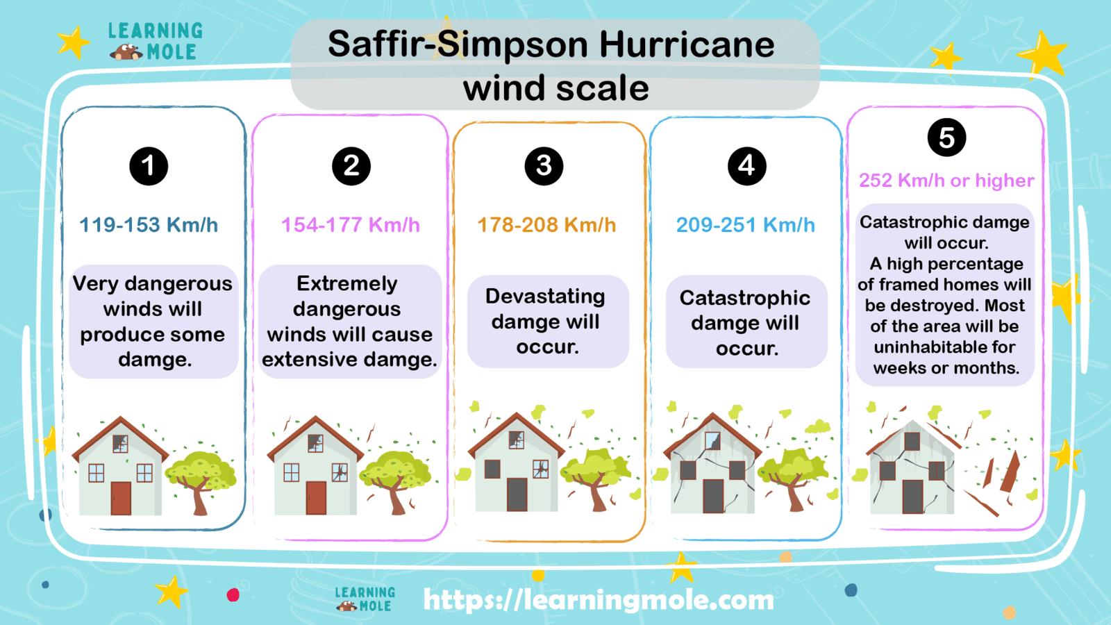
Hurricanes are categorized according to their wind speeds. They include:
Category 1 Hurricane: Wind speed ranges from 74 miles per hour to 95 miles per hour.
Category 2 Hurricane: Wind speed ranges from 96 miles per hour to 110 miles per hour.
Category 3 Hurricane: Wind speed ranges from 111 miles per hour to 129 miles per hour.
Category 4 Hurricane: Wind speed ranges from 130 miles per hour to 156 miles per hour.
Category 5 Hurricane: Wind speed ranges from over 157 miles per hour.
Hurricane Categories for Kids
Dissipation
As hurricanes continue to flow over warm tropical waters, they’ll continue to gather power and speed. Once they make landfall, they stop gathering power because they no longer have warm water to depend on to power themselves.
So, during landfall, they turn to be less and less organized as wind speeds fall dramatically. Finally, the hurricane will start to be divided into thunderstorms, before breaking down completely. While the hurricane floats over land, its high-speed winds and heavy rains result in massive damage, probably levelling entire towns in the process.
Hurricane facts: What are the types of Cyclones?
A cyclone represents a weather system marked by circling winds around a low-pressure centre. The wind direction around the canter is counterclockwise in the Northern Hemisphere, while in the Southern Hemisphere the wind direction is clockwise.
Coming in a large variety of sizes and settings, cyclones cause some of the most dramatic and complete violent weather on the planet, including the tropical cyclones known as hurricanes and typhoons. The science behind cyclones helps you realize where and why this weather phenomenon exists.
Hurricane facts: Tropical Cyclone
A tropical cyclone is defined by The National Weather Service as “a rotating system of clouds and thunderstorms that originated over tropical or sub-tropical areas.”
The significant tropical-cyclone basins include the North Atlantic (including the Caribbean), North Indian Ocean, Southwest Indian Ocean, Eastern Pacific, Western Pacific, Southern Pacific and Australian region.
Exactly tropical cyclones grow within 5 and 30 degrees of latitude, as they need ocean waters of around 80 degrees Fahrenheit to form. Winds funnel into a low-pressure disturbance, evaporating warm surface waters and unleashing energy as rising air condenses into clouds.
Hurricane facts: Hurricanes, Cyclone, Typhoons and Tornadoes
The terminology connected to tropical cyclones can be confusing because people call these violent storms by different names in different parts of the world. In the North Atlantic, the Caribbean, and the north-eastern Pacific too, people call them “hurricanes”.
In the Northwest Pacific, “a typhoon” is the most active tropical-cyclone basin in the world. While in the Indian Ocean and South Pacific, people call them “tropical cyclones” or “cyclones”. Tornadoes are called “cyclones,” yet they’re completely different storms.
Hurricane facts: Mesocyclones: Tornado Factories
Supercell thunderstorms are the name given to especially strong thunderstorms that display circling updrafts called mesocyclones. Rotating “wall clouds” may fall from mesocyclones and ultimately form a funnel cloud.
If a funnel cloud touches the ground, it turns into a tornado. The United States underwent approximately 1,700 mesocyclones in a year, with about 50 percent of these turning into tornadoes.
Hurricane facts: Midlatitude or Extratropical Cyclones
Hurricanes and typhoons may be popular to laypeople, but the cyclonic storms that grow along frontal boundaries in the middle latitudes are just as significant.
These cyclones, which grow where sharp temperature gradients exist between adjoining air masses, can be much larger than hurricanes, though their winds are generally weaker. A remarkable example of a midlatitude cyclone is the “nor’easter” that often affects the U.S. East Coast, particularly in winter.
Hurricanes frequently form over Arctic and Antarctic seas, sparked by freezing air moving over somewhat warmer ocean waters. In the Northern Hemisphere, scientists sometimes call polar lows “Arctic hurricanes,” because both their power source as well as their circling cloud bands are somewhat similar to a tropical cyclone. Polar lows often form quickly, sometimes in less than 24 hours, and it is not easy to forecast.
Hurricane facts: How Do Scientists Forecast Hurricanes?
Scientists can guess when hurricanes may happen depending on the complicated tools available. However, it is not guaranteed that the timing is accurate. Hurricane predictions can be divided into two categories: seasonal probabilities and the track of a current hurricane.
Scientists can’t give exact dates and times for hurricanes. However, they calculate the wind speed and the past occurrences of hurricanes to forecast possible hurricanes to form.
Scientists can track the path of a hurricane once it is formed using a lot of models. They can also forecast the intensity of the hurricane which is very important to give people chances to prepare for the hurricane. However, forecasting isn’t accurate enough.
Hurricane facts: How Do Hurricanes Get Their Names
Hurricanes used to be named by their geographical location and year until the 1950’s, when the U.S National Hurricane Centre developed a practice for naming hurricanes from the Atlantic Ocean. At the beginning hurricanes were named using female names in alphabetical order and the same names would be used every year. Later one both male and female names were used. Now the World Meteorological Organisation has established a strict procedure for naming hurricanes. Names used for hurricanes can be repeated, however, if a hurricane was deadly, life-threatening and costly, the name that the hurricane was named after is no longer used again.
Some names used for Hurricanes in the past that will never be used again are; Frances, Irene, Matthew, Otto, Gustav, Katrina, Charley and Sandy to name but a few.
Hurricane facts: Hurricanes in History
Hurricane Harvey
Hurricane Harvey was classified as a Category 4 storm that hit Texas on August 25, 2017. Harvey hit three times in six days and its peak was on September 1, 2017. The storm passed through the Caribbean and Mexico.
Harvey was classified as the strongest hurricane to hit Texas since Hurricane Carla in 1961. The hurricane was violent with maximum sustained winds of at least 130 mph. Let’s have a look at the damage caused by Harvey:
Two feet of rain dropped in the first 24 hours.
39,000 people were forced out of their homes and into shelters because of flooding.
It resulted in damaging 204,000 homes.
Right after the storm, at least 3,900 homes were still without power.
19 water systems were down as a result of the flood.
75 of the 275 schools of Houston Independent School District were closed due to flood damage.
one million vehicles were ruined in the Gulf area.
It caused 25 per cent of oil and gas production to shut down in the region.
U.S. average gas prices rose to $2.49 a gallon after the hurricane.
Between 25 and 30 per cent of Harris County was flooded.
Damage from Harvey was about $125 billion.
The storm caused 100 people in Texas alone to death.
Harvey is rated as the second-most costly hurricane to hit the U.S. since 1990.
Hurricane Dorian
Hurricane Dorian was a tropical cyclone that occurred in 2019. It is considered a category 5 storm. It was one of the most violent Atlantic hurricanes to make landfall. Winds reached 220 mph and storm surges reached 23 feet. Let’s check the damages caused by hurricane Dorian:
More than 2 million people along the coasts of Florida, Georgia, and North and South Carolina have to leave their homes.
Dorian resulted in about $3.4 billion in damage.
74 people lost their lives and 245 people were still missing a year later.
It resulted in flooding and mass destruction on the northwest islands of Abaco and Grand Bahama.
29,500 people don’t have homes or jobs.
The Grand Bahama International Airport, as an example for the damage of the infrastructure, was affected.
Hurricane Florence
Hurricane Florence hit near Wrightsville Beach, North Carolina, on September. 14, 2018. The wind reached 90+ mph winds. It was a violent and long-lived hurricane. The following are some damages caused by Florence:
More than 40 people, including many children, lost their lives across three South-eastern states.
Nearly 2 million people had to leave their homes.
Thousands of people were left without power.
It was the ninth most destructive storm for property damage in U.S. history.
15 people were killed because of flooding.
Florence caused house fires, electrocutions and traffic accidents.
Florence caused damage that was estimated at $24 billion.
North Carolina had the largest portion of the damage, with an estimated $22 billion in damage.
In South Carolina, the estimated damage was $2 billion and $200 million in Virginia.
In Georgia, the damage reached $30 million.
The rainfall exceeded 20 inches in some regions.
Florence was the reason for damaging thousands of structures, like toxic animal waste containment sites. This resulted in bacteria and hazardous chemicals being sent into the water.
Hurricane Andrew
Hurricane Andrew is considered a category 5 hurricane. It affected the Bahamas and the United States of America on the 16th of August, 1992. The highest sustained winds reached 175 mph. Here are some of the damages caused by Andrew:
The damage caused by Andrew was estimated at $27.3 billion.
65 people were killed because of the hurricane.
About 1.4 a million people were left without power
The U.S. State of Florida, in Dade County, had the largest loss of life.
In Florida, 25% of trees were pulled down by the storm.
The storm was the reason behind the killing of 182 million fish in the basin.
In Louisiana, the hurricane pulled down 80% of the trees.
In Louisiana, the storm killed 9.4 million fish.
In Louisiana, about 6,200 people moved to 36 shelters.
Hurricane Camille
Hurricane Camille was a category 5 hurricane that hit the Mississippi Gulf Coast region on the 17th and 18th of August 1969. The average sustained winds reached 210 mph. It is classified as the 2nd most intense hurricane to strike the continental US. Let’s check some of the damages caused by Camille:
143 people were killed along with Alabama, Mississippi, and Louisiana.
113 additional people were killed due to flash floods and landslides.
5,662 homes were ruined, and 13,915 homes experienced huge damage.
The total cost of damage was estimated at US$1.42 billion.
A huge number of cattle, deer, fish, and alligators drowned because of flooding.
Hurricane Irma
It is classified as category 5 that hit Florida on Sept. 10, 2017. The highest sustained wind reached 180 mph. It was the most violent hurricane to strike the United States since Hurricane Katrina in 2005. Let’s check some of the damages caused by the hurricane:
The total loss was estimated at $77.16 billion.
At least 134 people were killed because of the hurricane.
Coastal areas were evacuated, with around 6 million Florida residents.
In Florida, more than 7.5 million homes became without electricity.
In Carolina, 100,000 homes were left without power and five died because of storm-related issues.
In Cuba, about 150,000 homes were ruined.
Hurricane Katrina
Hurricane Katrina was the most violent hurricane to hit the United States in August 2005. Katrina where Florida, Louisiana, Alabama and Mississippi were the most affected states by the hurricane. It is classified as a category 5 hurricane. Let’s have a look at some of the damages caused by Katrina:
At least 1800 people were killed because of Hurricane Katrina.
80% of the city of New Orleans flooded to a maximum depth of 20 feet.
Around three million people were left without power because of the storm.
The total damage was estimated at $125 billion in 2005.
40% of all the deaths in Louisiana were because of drowning.
Between 300,000 to 350,000 vehicles were also damaged, as well as 2,400 ships and vessels.
Hurricane Mathew
It is classified as a category 5 hurricane. Mathew hit Haiti Cube on October 4, 2016, in the evening. The highest sustained wind reached 160 mph. Let’s check some of the damages caused by Mathew:
546 deaths were estimated because of the hurricane.
The total loss was estimated at $10 billion.
Matthew was the most awful disaster to hit Haiti since the 2010 earthquake.
The most general effects of the storm in the U.S were flooding and power outages.
In Haiti, damage was estimated at just over $1 billion.
Hurricane Michael
It is classified as a category 4 hurricane. It hit near Mexico Beach on Oct. 10, 2018. The wind speed was 160 mph. Scientists stated that, in recorded history, Hurricane Michael was the first category 4 storm to make landfall in the northeast Gulf Coast. Let’s check some of the damages caused by Michael:
35 people were killed because of the hurricane.
Initial property damage was estimated at $4.5 billion.
Florida’s forestland damage was estimated at $3 billion.
About 375,000 people were evacuated from their homes.
In Cuba, about 70% of the offshore went without power.
Most of the city’s TV and radio stations stopped working because of the hurricane.
Hurricane Ophelia
It was one of the strongest Atlantic tropical cyclones. It hit Ireland in October 2017. It is classified as a category 3 storm. It is ranked as the tenth consecutive hurricane in the Atlantic Ocean. Let’s check some of the damages caused by Ophelia:
The estimated damage caused by the storm was more than $70 million USD.
More than 385,000 homes went without power.
The country was shut down for 2 days.
Three people in Ireland were killed because of the hurricane.
43% of the people In Dublin said their property was damaged.
Hurricane Tomas
Hurricane Tomas began to hit the Caribbean islands on Friday October 29, 2010. The highest sustained winds reached 100 mph. 10 countries in the region were affected by the hurricane. Let’s check some of the damages caused by Tomas:
15 people were killed on the island because of the hurricane.
Roads and infrastructure were destroyed.
Bridges and roads were completely damaged.
The estimate of the total loss was about $652 million.
Hurricane facts: What is the Difference between a Hurricane and a Tornado?
Both hurricanes and Tornadoes are natural phenomena. They are fatal and cause a lot of damage. They cause strong sustained winds. Let’s have a look at some of the differences between hurricanes and tornadoes:
the Difference between a Hurricane and a Tornado
Hurricanes
Tornadoes
It occurs in the warm water tropics
It occurs on land
It can be up to hundreds of miles wide
It is usually less than a quarter-mile wide
The highest sustained winds can reach 100 mph
The wind can reach 300 mph
Around 10 tropical storms can occur in a year in the Atlantic Ocean
From 800 to 1000 tornadoes in a year in the U.S.A
It can be predicted several days ahead
It can be predicted 15:30 minutes ahead
The greatest damages are caused by floods
The greatest damages are caused by winds
It is huge but slow
It is not predictable but fast
It occurs in warm areas
It occurs anywhere
Diameter ranges from 60 to 1300 miles
Diameter is about 100 meters
Hurricane facts: Some Safety Precautions during Hurricanes
Explain to the kids what’s expected during hurricanes.
Get ready with the emergency bag that includes flashlight, blanket, medical aid, and any other personal stuff.
Plan for the evacuation process.
Practice the evacuation plan.
In case no evacuation is needed, stay indoors.
Buy all the necessary outdoor objects.
Buy enough food and water.
Stay away from windows.
Move to a shelter if needed.
Be careful of flooding that can occur after hurricanes.
Don’t drive in flooding water.
Don’t drink tap water unless it is officially allowed.
Always be updated with the weather reports.
Cover any glass area and windows with boards.
Hurricane facts: Some Hurricane Survival Stories
Story of Carol Park: The story goes back to September of 1961 in the Gulf of Mexico when Carol was only 10. She witnessed Hurricane Carla which is a category 5 hurricane. She was playing outdoors and her family didn’t take any precautions. There were heavy rains and violent winds. She still remembers the mixed feeling of fear and excitement.
Story of RJ Cywinski: He was 11 years old. His family had to evacuate their home. They left for a shelter with their pets. They found a lot of people there as well. He felt terrified while they were driving to the shelter as if the storm was following them.
Story of Bill: Bill witnessed hurricane Sandy in November 2012 in New York. He and his family were under the impression that they got ready for the hurricane. They prepared the emergency bag and all the needed supplies. However, the hurricane was much stronger than expected. Trees bent down and the power went down as well. Roads were blocked by the falling trees so there was nowhere to go. They had to stay at home away from the windows until the hurricane passed.
Story of Christina: She witnessed 3 major hurricanes in the area of Virginia in 2003, 2011, and 2018. During the first hurricane, power went off for 13 days. They didn’t have access to gas or ice. During the 2nd hurricane again power went off for 7 days. The wind was terrifying. The third experience, power went off for 5 days. Some roads were blocked.
Hurricane facts: Interesting Projects for Kids to Make a Hurricane
It is exciting for kids to design a project that represents hurricane formation. Here are two projects that kids can do by themselves.
Project One
Supplies needed:
A bowl of water
Water
Food colouring
Steps:
Bring a bowl of water
Spin the water
Pour water into the bowel
Add food coloring
Now watch the bands spin-out from the center then lose energy
Project Two
Supplies needed:
A bottle of water
Hair conditioner
Glitter
Steps:
Get a bottle of water
Add hair conditioner to the water bottle
Add the glitter
Spin the bottle
Now you can watch the hurricane
Hurricane facts: List of Books About Hurricanes for Kids
Jumbie God’s Revenge by Tracey Baptiste
Carrie and the Great Storm by Jessica Gunderson & illustrated by Matt Forsyth
The Magic School Bus Inside A Hurricane by Joanna Cole & illustrated by Bruce Degen
Skylark and Wallcreeper by Anne O’Brien Carelli
I Survived Hurricane Katrina, 2005
Hurricane Heroes in Texas
Let’s Read and Find Out scientific series
Hurricane Lesson Resources and Activities
The Magic School Bus
Hurricanes! (New Edition) Written & illustrated by Gail Gibbons
Miss Twiggley’s Tree Written & illustrated by Dorothea Warren Fox
Storm Runners
Hurricane Child
Scout Storm Dog
Hurricane facts: Frequently Asked Questions About Hurricanes
When is Hurricane season?
The Atlantic hurricane season is the period in a year from June through November when tropical cyclones form in the Atlantic Ocean.
TheSouth Pacific cyclone seasonlasts from January until the end of April.
The Eastern Pacific hurricane seasonis the period in a year from mid-May until mid-October. Around this period, Typhoons start forming in the Western Pacific.
The Western Pacific cyclone season is between May and October.
What’s the difference between a hurricane and a typhoon? If it’s above the North Atlantic, central North Pacific or eastern North Pacific oceans a tropical storm is known as a hurricane. If it occurs over the Northwest Pacific Ocean, around East Asia, it is known as a typhoon.
What’s the difference between a hurricane and a cyclone? As we know, when a tropical storm develops over the the North Atlantic, central North Pacific, and eastern North Pacific it is called a hurricane. When a tropical storm forms over the South Pacific and Indian Ocean it is known as a cyclone.
What’s the difference between a hurricane and a tornado? Unlike the others spoken about which are distinguished from where they occur, the difference between a hurricane and a tornado is the size and lifetime of it. Hurricanes are typically much larger and have a longer lifetime than that of a tornado.
What happens when you are in the eye of the storm?
The eye of the storm is actually the calmest part of a hurricane and is one of the safest places you can be during a hurricane, besides being completely outside the hurricane. Skies are often clear above the eye and winds are light compared to the outer hurricane. The eye is so calm because the strong winds that spin around never reach the centre.
How long do Hurricanes last?
The part of the hurricane that impacts us on land can last from a few hours up to a full day. The actually whole lifespan of a hurricane can last from a few days to a few weeks from when it forms in the ocean.
Conclusion
To recap, hurricanes are considered natural disasters. They are divided into categories depending on how violent they are. There are 6 stages for hurricanes. They cause mass destruction. There are a lot of hurricanes that hit many countries.
As well, many writers wrote books only about hurricanes for kids and adults too. There are many activities and projects for hurricanes that kids can do. A lot of people spoke and even wrote about their experiences during hurricanes and how they survived.
Dmitri Mendeleev must be highly organised to sort the elements the way they are on the periodic table! Let's learn five popular periodic table facts for kids. Periodic Table Facts...
One of my favourite dinosaurs is T-Rex! Let's discover five terrific T-Rex facts for kids. T-Rex Facts for Kids Fact Number 1: The Name Tyrannosaurus Rex Means ‘Tyrant Lizard King’...
Stegosaurus had a special name for his tail! What do you think it is? Let's discover five spectacular Stegosaurus facts for kids. Stegosaurus Facts for Kids Fact Number 1: The...


Leave a Reply